


Iraq Deposits Maritime Boundary Map with the UN to Strengthen Legal Position
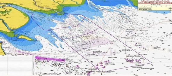
Basra / NINA / The Director General of the Iraqi State Company for Ports, Farhan Al-Fartousi, announced on Saturday that Iraq has officially deposited a map of its maritime domains and corresponding coordinates with the United Nations, in a step aimed at securing the country’s maritime rights and strengthening its negotiating position in maritime boundary files.
In a statement, Al-Fartousi said that Iraq’s Permanent Mission to the United Nations formally submitted the map and coordinates on February 18, and that they were circulated to UN member states, following extensive technical work carried out by specialized Iraqi committees and joint meetings involving several government bodies.
He noted that the Ports Company maintained permanent technical representation within these committees and contributed its expertise to support the preparation of the maritime documentation. The deposited map covers Iraq’s entire maritime domains, including internal waters, territorial waters, the contiguous zone, and the exclusive economic zone.
Al-Fartousi stressed that this step enhances the protection of Iraq’s maritime rights and reinforces the country’s legal and technical standing in any international discussions or procedures related to maritime boundary demarcation, particularly concerning the Khor Abdullah file beyond marker (162), providing Iraq with stronger international backing. /End